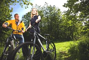
About
Distance: 35 miles
Grade of walk: Strenuous
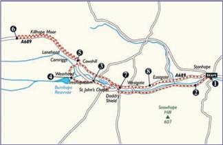
1. Leaving Durham Dales Centre, Stanhope, turn right onto A689;
2. Turn left onto B6278 (signed Barnard Castle, Egglestone) then turn right immediately after Stanhope Bridge along south side of river to Daddry Shield.
3. On meeting the A689 turn left and continue to Ireshopeburn taking the 2nd left in the village onto Causeway Road.
4. After climbing for approximately 1 mile turn right (going through 2 gates) to Burnhope Reservoir;
5. Go along edge of reservoir, keeping left as road forks (signed Cowshill) to emerge at T-junction in Cowshill, turn left and follow to Killhope Lead Mines.
6. From Killhope retrace to Cowshill and turn left onto minor road on north side of the river;
7. At T-junction turn left up the hill then bear right at High Barnes Farm to emerge back onto A689 at Bridge in Daddry Shield;
8. Turn left to return to Stanhope on A689.
This route passes near to the following Taste Durham establishment: The Durham Dales Visitor Centre.
TripAdvisor
Facilities
Accessibility
- Distance: Over 20 Miles
- Grade: Hard
- Route Surface: On Road
- Theme: Breathtaking Views
- Theme: Heritage
- Theme: Nature
Provider Features
- Grade (Strenuous)
- In countryside
- Route Surface (On Road)
- Suitable For (Mountain Bike/Tourer)
- Time (Full Day)
Opening Times
| 2026 (1 Jan 2026 - 31 Dec 2026) |
|---|
Map & Directions
Map Link
View Map
Road Directions
Travel to Stanhope along the A689. The Dales Centre is west of the Market Place along the main road.
Public Transport Directions
Stanhope is served by the Weardale Travel 101 bus.
Access Information


 to add an item to your Itinerary basket.
.png)